Geodiversity
Conserving what's underfoot

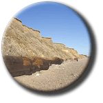
Pakefiield Cliffs in Suffolk, part of the
Pakefield
to Easton Bavents
SSSI.
It is easy to overlook geodiversity, although it is frequently
staring us in the face: the rocks, soils, landforms and landscape-forming processes
that make up the substrate for all living things, including human life. Geodiversity
is a term for these non-biological aspects of nature. It is an unfamiliar term,
but one which is being used with increasing frequency in the worlds of nature
conservation and planning policy.
Geodiversity may be defined as the natural range (diversity) of geological
features (rocks, minerals, fossils, structures), geomorphological features
(landforms and processes) and soil features that make up the landscape. It
includes their assemblages, relationships, properties, interpretations and
systems.
The standard reference book is ‘Geodiversity’ (Gray
2004), and the above definition is adapted from this source.
Britain
can be proud of its geodiversity – it has more geological diversity
than any other comparable area in the world. But until recently, geodiversity
has been an under-valued part of nature conservation in the UK.
The statutory conservation of geological and geomorphological
features is part of the remit of National
Parks , National
Nature Reserves
 and Sites
of Special Scientific Interest (SSSIs)
 . These were established
under the National Parks and Access to the Countryside Act 1949, and form
a network of statutorily protected areas. There are about 2,300 SSSIs in
Britain designated for their Earth heritage interest (about one third of
the total). They were identified under the Nature Conservancy Council’s Geological Conservation Review
process. In Northern Ireland SSSIs are called Areas of Special Scientific Interest.
Legal provisions for SSSIs were strengthened under the Wildlife & Countryside
Act
 (1981 as amended 1985) and the Countryside
and Rights of Way Act (2000)
 .
The Town & Country Planning Act (1947 and 1990) ensured that local authorities
consulted the Nature Conservancy and its successor bodies on planning applications
relevant to SSSIs and allowed them to adopt appropriate planning policies.
The non-statutory conservation of geodiversity is principally
carried out under the Regionally
Important Geological/geomorphological Site (RIGS) scheme.
RIGS fall under the category of non-statutory ‘Local Sites’ (DEFRA
2006), but the network is not yet fully extended across the country (UKRIGS
2006). RIGS are treated by Planning
Policy Statement 9 (PPS9) as under a category
of Regional and Local Sites (ODPM 2005). PPS9 views geo-conservation as part
of the Government’s objectives for sustainable development, nature conservation
and social renewal. It says local planning authority policies should attach ‘appropriate
weight’ to designated sites and also ‘geological interests in the
wider environment’. Although RIGS enjoy no legal protection many
local authorities give them conservation status in their planning policies
such as Local Development Framework (LDF) and Minerals and Waste Development
Framework documents. An opportunity exists to include baseline geodiversity
indicators in the Sustainability Appraisal process which is part of the LDF
process.
Non-statutory geo-conservation may also be an important part of landscape
designations such as the AONBs and Heritage Coasts in England and National
Scenic Areas in Scotland. The National
Trust
 and the Wildlife
Trusts
 are examples
of conservation organisations which routinely protect geodiversity as part
of their remit.

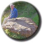
Valuing geodiversity: this glacial erratic
is a designated RIGS site in Suffolk. The Local Geodiversity Action
Plans (LGAPs) concept was first proposed by English
Nature in
2001 and modelled on the successful BAP format. LGAPs aim to provide a sustainable
framework for regional and local geo-conservation in defined areas, involving
a wide range of partners to ensure local support for their objectives. The
LGAP process is gathering momentum across Britain. As at 2007, 27 LGAPs have
been launched or are in development, covering areas such as counties, AONBs
and National Parks, and at least three mineral aggregate companies are preparing
GAPs of their own. A National GAP is at drafting stage, to provide a national
framework for geodiversity conservation.
Typically, a GAP will
- audit the geodiversity resources of a given area,
- plan the conservation and management of its Earth heritage resources,
- promote geodiversity in the policy and practice of local agencies and organisations,
- promote geodiversity awareness through education and communication, and
- sustain the LGAP process by securing ongoing resources for its implementation.
While a ‘torrent of effort’ is
being put into biodiversity conservation in Britain, geodiversity conservation
has until lately been a poor relation. However the linkage between geodiversity
and biodiversity is being increasingly recognised and promoted at a national
level (English Nature 2004). The Natural Areas concept developed by English
Nature in the 1990s as a strategic, landscape-scale approach to nature conservation
has geodiversity at its core by defining 97 terrestrial Areas based on rocks,
soils and landforms (English Nature 1998). Geodiversity is also contributing
to landscape conservation, which is being integrated into the planning system
through the Landscape Character Types concept, placing places human settlement
and land-use patterns into their context of rock types, soils and landforms
(Landscape Character Network 2007). In 2006 English Nature, the Countryside
Agency and DEFRA’s Rural Development
Service jointly published ‘Natural Foundations: geodiversity for people,
places and nature’ as major a step towards an integrated approach to
environmental conservation, management and enhancement, by linking biodiversity,
landscape and human life (Stace & Larwood 2006).
The above was adapted from the article ‘A Geodiversity Action Plan for
Suffolk’ by Tim Holt-Wilson (Transactions of the Suffolk Naturalists
Society, forthcoming 2007), with acknowledgement to Gray (2004) for detail
on legislative background.
- DEFRA (2006). Local Sites. Guidance on their identification, selection
and management. Department for Food and Rural Affairs.
- English Nature (1998). Natural Areas: nature conservation in context (CD-ROM).
Peterborough.
- English Nature (2004). Linking Geology and Biodiversity. Peterborough:
English Nature Research Report, No. 562.
- Gray, M. (2004). Geodiversity - valuing and conserving abiotic nature.
Wiley, Chichester.
- Landscape
Character Network (2007). East of England. Viewed
7 June 2007.
- ODPM
(2005). Planning Policy Statement 9: biodiversity and geological
conservation. Office of the Deputy Prime Minister.
- Stace, H., and Larwood, J. (2006). Natural Foundations: geodiversity for
people, places and nature. English Nature, Peterborough.
- UKRIGS (2006). UKRIGS Development Strategy 2006-2010. The Association of
UK RIGS Groups.


